
A new paper co-authored by Dr. Pierrat is out now in the International Journal of Applied Earth Observation and Geoinformation. “Utilizing thermal infrared spectroscopy data to map lithology and mineral alteration in geothermally active areas,” led by Federico Rabuffi with colleagues at Italy’s Istituto Nazionale di Geofisica e Vulcanologia (INGV) and NASA’s Jet Propulsion Laboratory, tests how well thermal infrared (TIR) spectroscopy can separate rock types and pick out hydrothermal alteration in landscapes shaped by geothermal activity.
The physical basis is that most rock-forming minerals — quartz, feldspars, and other silicates — have diagnostic emissivity features in the 8–12 µm thermal infrared, driven by Si–O bond vibrations, and the secondary minerals produced when hot, acidic geothermal fluids react with rock (clays such as illite, plus silica, sulfates, and carbonates) carry their own spectral fingerprints. That makes TIR spectroscopy a fast, non-contact way to map both the underlying geology and the alteration “halos” that mark where geothermal fluids reach the surface — information that is otherwise slow and expensive to collect by hand in the field.
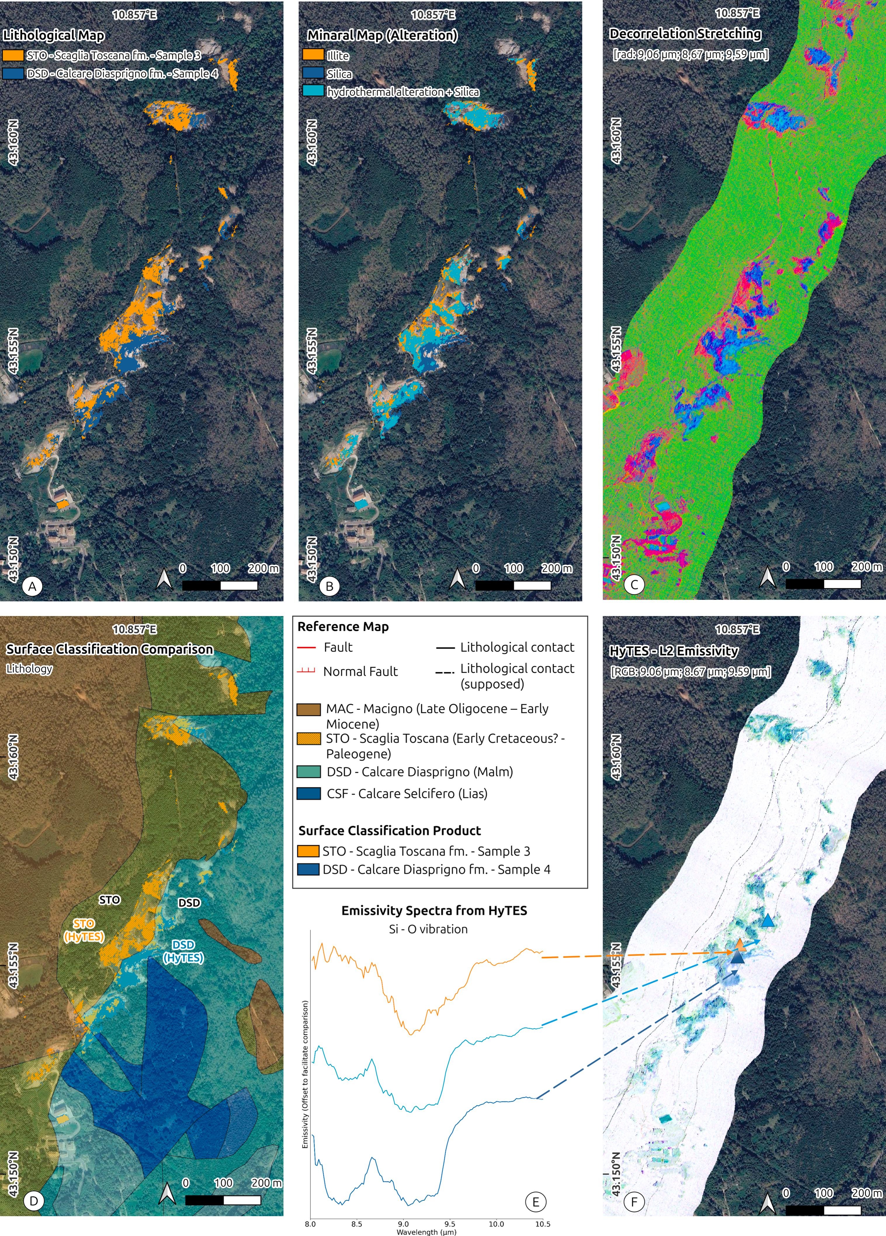
The team worked with airborne data from HyTES, the Hyperspectral Thermal Emission Spectrometer, over a geothermally active area in Tuscany, Italy, where surface hydrothermal alteration sits alongside a mix of sedimentary formations. From the HyTES radiance and Level-2 emissivity products they derived a lithological map and a map of alteration mineralogy, picking out illite, silica, and combined hydrothermal alteration plus silica, and separating sedimentary units including the Scaglia Toscana and Calcare Diasprigno formations. A decorrelation stretch of selected radiance bands sharpened the contrast between altered ground and surrounding vegetation and rock, and emissivity spectra extracted at sample locations show the shape of the Si–O feature near 9 µm shifting from one formation to the next.
To check the result, the HyTES-derived lithological classification is compared against the regional reference geology from the Database Geologico della Regione Toscana. The TIR-based surface classification recovers the mapped distribution of the main formations, showing that hyperspectral thermal data can reproduce geological boundaries and flag hydrothermal alteration from the air.
HyTES is a JPL airborne imaging spectrometer that doubles as a testbed for spaceborne thermal infrared missions, including the planned Surface Biology and Geology (SBG) thermal instrument. Studies like this one help establish what lithological and mineralogical information those future global, repeat-coverage datasets will be able to deliver.
Rabuffi, F., Hook, S. J., Musacchio, M., Silvestri, M., Cawse-Nicholson, K., Buongiorno, M. F., & Pierrat, Z. A., 2026. Utilizing thermal infrared spectroscopy data to map lithology and mineral alteration in geothermally active areas. International Journal of Applied Earth Observation and Geoinformation, 153, 105550. doi.org/10.1016/j.jag.2026.105550