
A new paper co-authored by Dr. Pierrat is out now in Remote Sensing of Environment. “Integrating Landsat and ECOSTRESS to explore the value of additional thermal infrared satellite observations for field-scale evapotranspiration mapping,” led by Hui Liu, asks a practical question for water management: how much do we actually gain by adding more thermal satellite observations to Landsat when mapping evapotranspiration (ET) at the scale of individual fields?
Landsat has long been the foundation for field-scale ET mapping, but it only revisits a given location every 8–16 days, and clouds often remove some of those overpasses. ET between clear-sky images has to be interpolated, which can miss rapid changes from irrigation, rain, or heat. Adding thermal observations from other satellites is an obvious way to fill those gaps, but how much it helps depends on when and how well the extra observations are made, and on the landscape being mapped.
To test this, the team used NASA’s ECOSTRESS thermal radiometer on the International Space Station as an additional thermal source on top of a Landsat baseline. They built a Google Earth Engine implementation of the Disaggregated Atmosphere-Land Exchange Inverse (DisALEXI) model with the Data Mining Sharpener to generate Landsat-based ET, then enhanced it with ECOSTRESS observations. The resulting ET time series were validated against 25 flux tower sites spanning a range of land-cover types and climate zones across the contiguous United States.
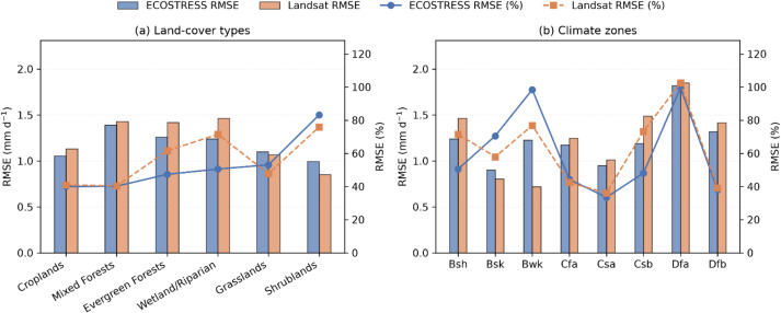
Adding ECOSTRESS reduced interpolation errors and improved the temporal consistency of ET at most sites. How much it helped depended on two things: how far ECOSTRESS shortened the effective gaps between Landsat observations, and how accurate the ECOSTRESS ET retrieval was on its overpass days. The largest improvements came when ECOSTRESS cut Landsat’s sampling gaps by about half while maintaining high scene quality. Because the Space Station’s orbit samples different times of day, overpass time mattered too: ECOSTRESS land surface temperature acquired between 10:00 and 14:00 produced the most reliable daily ET.
The results support building ET products from multiple thermal satellites, and they help address a key open question about the value of more frequent thermal observations, with implications for upcoming missions such as the Surface Biology and Geology (SBG) thermal instrument.
Liu, H., Yang, Y., Anderson, M. C., Gao, F., Hain, C. R., Volk, J. M., Pierrat, Z. A., Cawse-Nicholson, K., Melton, F. S., Lee, C. M., Purdy, A. J., Duan, W., Li, T., & Wang, J., 2027. Integrating Landsat and ECOSTRESS to explore the value of additional thermal infrared satellite observations for field-scale evapotranspiration mapping. Remote Sensing of Environment, 348, 115738. doi.org/10.1016/j.rse.2026.115738